
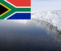
Antarctica and southern oceans islands
Antarctica – the last true wilderness
Antarctica, the continent that surrounds the South Pole, remains the most mysterious continent on earth. No-one lives there permanently.
Antarctica is the coldest, windiest and driest place on earth. It is almost entirely covered in ice. The lowest temperature measured was -88 degrees Celsius. In the interior, wind speeds reach up to 350 km/h. The annual rainfall is about 50mm inland and 35mm along the coast (South Africa’s average annual rainfall is 464 mm, and the world average is 857 mm). During summer, Antarctica has 24-hour daylight, no nights. During winter, Antarctica has 24-hour nights when it is continually dark for about one month.
- Antarctica is so cold because it is:
- surrounded by an ocean with cold currents;
- the windiest place on Earth;
- completely covered with snow. Since snow is white, it reflects rather than absorbs the sun’s rays; and
- situated at an extremely high altitude (average 2 500 m).
Although the region is harsh and very few people live there, it is very vulnerable.
a. South Africa in Antarctica
South Africa’s involvement in Antarctica and the Southern Ocean Islands dates back to the earliest voyages of discovery, due to the then Cape of Good Hope’s position as a stop-over for explorers, whalers and sealers (people hunting whales and seals).
In 1959, the first South African expedition to the Antarctica was undertaken. The expedition established a permanent presence for South Africa in Antarctica which is still there to date. South African took over an abandoned Norwegian base on the edge of the ice shelf, some 4 000 km south of Cape Town. This base was replaced several times, because a base built on the ice shelf drifts out to sea with the ice with time and is eventually covered with snow.
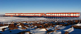
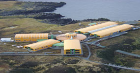
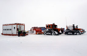
The most recent South African base, SANAE-IV, is located 170 km inland, built on a rocky outcrop peeping out of the white snow. The new base was completed in 1997. The frame of the base is made of steel and the outer layer is rigid, pre-constructed foam and fibreglass panels. The base is built on stilts to allow for wind and snow to flow underneath the base and to thus prevent the accumulation of snow on top of the base. The roof and bottom panels are painted bright orange which makes it easier to see the base from the air. The living quarters are heated by the heat exchangers of the electric power generators. Fresh water is obtained by melting snow.
b. How to get there
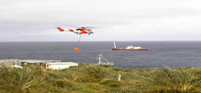
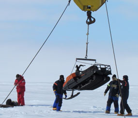
Antarctica is about 4000km away from South Africa. It takes 10-15 days to travel there by ship, the time depending on how much ice there is along the way. It can only be reached between November/December and April/May. The SA Agulhas (and now the now the new SA Agulhas II is the Department of Environmental Affairs’ research and supply ship. The vessel transports people and cargo to its three bases in Antarctica and on Marion and Gough Islands. The ship is therefore also a scientific platfor allowing for research to be conducted, weather observations to be made and weather to be released as it sails.
Much of the South African researchers’ work in the Antarctic and Southern Ocean Islands region is aimed at protecting the fragile environment. The mission of the Department of Environment’s is to increase our understanding of the natural environment and life in the area through appropriate research, science and technology.
c. Who owns Antarctica?

The Antarctic continent does not belong to any state or government. South Africa and 48other member nations belong to the Antarctic Treaty. Through the Antarctic Treaties Act, Act No. 60 of 1996and National Environmental Management Act (NEMA), Act No. 107 of 1998,it is determined how the area is managed. Countries that sign this treaty undertake to ensure that the Antarctic region will only be used for peaceful and scientific purposes and to protect and preserve the environment.
d. Indigenous plants and animals
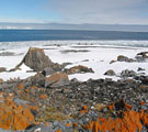
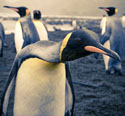
Antarctica is a hostile environment and most of the plants and creatures in South Africa will not survive there. Lichen – a plant composed of fungus and algae – is found on the rocky outcrops. Invertebrates (animals without backbones) such as ticks and mites are also found there. Larger land animals include penguins and seals. The surrounding ocean is the home of whales, which feed on krill and sometimes seals and penguins. A few bird species are also found on Antarctica.
e. Science in Antarctica

Studies done in Antarctica are critical to enhancing the understanding of the entire Earth system. Signals that researchers pick up in Antarctica tell us more about global climate changes in the past, as well as possible future changes. The following are some interesting research projects that are being undertaken in by South Africans in Antarctica..
- Physical science
This is focused on geomagnetic and space weather related observations. It includes physics and chemistry. Physical science research is conducted all year round in Antarctica. Experiments include a network of high-frequency radars used to study the Earth’s ionosphere; observing geospace (the area of space that surrounds Earth) from Earth; research on cosmic rays (very high energy charged particles from the cosmos); and observations of the magnetosphere.
This physical science observations done in Antarctica is important because space weather, resulting from outbursts on the sun, always has a much greater impact near the poles, than anywhere else on Earth.
- Studying the oceans (Oceanography)
Studying the oceans south of Africa contributes to our understanding of the weather and climate of Southern Africa. Biodiversity in Antarctica and the islands and the Southern Ocean provide exciting research opportunities.
Oceanographers from DEA and partner institutions study the importance of the main current that flows around Antarctica – called the Antarctic circumpolar current – and how it changes in temperature, salinity, and density. They also study the effect of this current’s movement and velocity on the Prince Edward Island ecosystem.
- Engineering science
Engineers do research into how South Africa can ensure a sustainable presence in Antarctica. They study energy generation and waste management, solar and wind energy, reducing air pollution, heating and ventilation of the bases, and improving the living conditions at the bases. They also study energy and waste management of the base, renewable energy systems and the impact and cost of diesel engines which are used to generate electricity and power vehicles in Antarctica. This team is also developing better support systems for SANAE IV, which is vulnerable because of the snow that accumulates around the base.
- Biological science
There may not seem to be much biological activity in Antarctica, until one takes a closer look. Studies are about the effects of humans on the micro arthropods (animals that have segmented bodies and jointed, hollow legs such as spiders, insects and crustaceans) of Antarctica.
- Weather
The South African Weather Service (SAWS) collects data on weather and the climate in Antarctica and on the Southern Ocean Islands, and have weather offices at SANAE IV, Marion and Gough Islands. They also gather data on ozone levels at SANAE, which can be used to study trends in ozone depletion.
- Each expedition is made up of the following personnel:
- 1 Doctor
- 2 Diesel mechanics
- 1 Electrical engineer / technician
- 1 Mechanical engineer / technician
- 1 Electronic engineer / technician
- 1 Senior meteorologist
- 2 Physicists (electronic / electrical engineers)The over-wintering team spends approximately 15 months on the continent; of which 10 months is in total isolation until the next relief team arrives.
Marion Island
Marion Islandlies in the Southern Indian Ocean. Marion Island is 19 km long by 12 km wide, and the two islands (Marion and Prince Edward) have a combined area of 316 square km and politically form part of South Africa's Western Cape Province. The islands are volcanic in origin, with Marion having many hillocks (secondary craters) and small lakes. Prince Edward Island has spectacular cliffs up to 490m high on its south western side.
There is little vegetation, except for lichen, in the island's centre. Elsewhere the vegetation is mainly mosses and ferns, and the terrain is very boggy. This is due to the abundant snow and rain. There are no trees, due to the persistent, strong westerly winds commonly termed the ‘Roaring Forties’.
Marion Island was annexed in 1948 and therefore became a South African territory. Since then biological/environmental research is a major function of the Marion Island base (weather data collection being the other). Close to 1000 scientific papers and dozens of post-graduate thesis have been produced from research on Marion, and the long-term biological monitoring programmes provide exceptional research potential into the rate and impacts of climate change as a result of global warming.
This site, covering 37 500 hectares was designated by the Government of the Republic of South Africa for inclusion in the List of Wetlands established under the ‘Convention on Wetlands of International Importance’, an intergovernmental treaty signed in Ramsar, Iran in 1971 to promote the conservation and sustainable use of wetland areas worldwide. The Prince Edward Islands were included within the Convention on 22 May 2007 as Ramsar Site No. 1688. The protection and management of this site falls within the responsibility of the Branch: Oceans & Coasts. The Prince Edward Islands are the first to be declared Ramsar Wetland sites and therefore added to the South African Ramsar list.
In 1995 the Prince Edward Islands was declared the Special Nature Reserve under the Environment Conservation Act, Act No. 73 of 1989. With the aim to protect this Special Nature Reserve and in an effort keep these islands’ environment as pristine as possible, the Director-General has appointed the Prince Edward Islands Management Committee to manage these two islands with the support of the Prince Edward Islands Management Plan. The Management Plan attempts to ensure that the necessary protection is afforded to the island’s fragile ecosystems, within the context of both national and international legal obligations, while facilitating the scientific research necessary to underpin its effective implementation.
- The research on Marion Island focuses mainly on the following themes:
- Weather and Climate studies
- the interactions between marine and terrestrial systems
- the life histories of seals, seabirds and killer whales
- the life histories of birds found on Marion
- the structure and functioning of terrestrial ecosystems and
- the structure and functioning of near shore ecosystems
- The station on Marion Island is usually manned by the following personnel:
- 1 Senior Meteorologist
- 2 Assistant Meteorologists
- 1 Medical Orderly
- 1 Radio Technician
- 1 Diesel Mechanic
- 1 Base Engineer
- 1 Environmental Conservation Officer
- Various Field Assistants/Biologists
The overwintering team stays there for 15 months until the new relief team arrives.
The year 2011 marked the commissioning of the new Marion Island research base. The base was commissioned on 18 March 2011 when the Deputy Minister, Mrs Hendrietta Bogopane-Zuluof the National Department of Public Works officially handed the base over to the National Department of Environmental Affairs. Receiving the keys on behalf of the Department was Dr Monde Mayekiso, Deputy Director-General: Oceans and Coasts. The new base houses approximately 80 participants, including the expedition teams, as opposed to the old base which could only accommodate 64 relief people.
Gough Island
South Africa has been operating a weather station on Gough Island since 1956. This weather office operates the same as stations in South Africa with hourly climate observations and twice daily upper-air ascents.
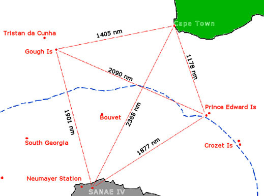
Gough Island (also known historically as Diego Alvarez) is a volcanic island rising from the South Atlantic Ocean to heights of over 900 metres (2950 ft) above sea level with an area of 35 square miles (91 km²). It is a dependency of Tristan da Cunha, which in turn is a dependency of the British overseas territory of St Helena. The land the station is built on is leased by South Africa under contract and is magistrated as a district of Cape Town.
It is uninhabited except for the 6 to 8 expedition members of the weather station and is thus one of the most remote places with a constant human presence. It is a lonely place, about 400 km (220 mi) southeast of the other islands in the Tristan da Cunha group, 2700 km (1700 mi) from Cape Town, and over 3200 km (2000 mi) from the nearest point of South America.
Gough and Inaccessible Islands form a protected wildlife reserve, which has been designated a World Heritage Site by the United Nations Education, Scientific and Cultural Organisation (UNESCO). It has been described as one of the least disrupted ecosystems of its kind and one of the best shelters for nesting seabirds in the Atlantic. In particular, it is host to almost the entire world population of the Tristan Albatross and the Atlantic Petrel.
However, this status is now in doubt as in April 2007 researchers published evidence that predation by introduced house mice on seabird chicks is occurring at levels that might drive the Tristan Albatross and the Atlantic Petrel to extinction. The island is also home to the almost flightless Gough Island Moorhen.
The station on Gough Island is manned by the following personnel:
- 1 Senior Meteorologist
- 2 Assistant Meteorologists
- 1 Medical Orderly
- 1 Radio Technician
- 1 Diesel Mechanic
- Various Field assistants/Biologists
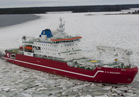
SA Agulhas II
The new South African polar research and supply vessel was officially launched and named (SA Agulhas II) on Thursday, 21 July 2011, in Rauma, Finland. The SA Agulhas II is dedicated to the memory of Miriam Makeba.
The new vessel will take over from the SA Agulhas as South Africa’s new Antarctic research and supply vessel. For South Africa this represents a major investment and signals the Department of Environmental Affairs’ commitment and intent in contributing to the understanding of the Earth as a functioning, integrated unit.
The Department recognise that with the oceans covering more than 70% of the planet’s surface, understanding the oceans is key to understanding the Earth. For similar reasons South Africa remains committed to its research and management of the South African Sub-Antarctic Island Territories of Prince Edward and Marion Island; and to ongoing work on the South African Base on Antarctica. Understanding the functioning of the Earth System cannot exclude the oceans, and the southern oceans and Antarctica provide an ideal environment to focus on the natural dynamics of earth, ocean, atmosphere and space. For South Africa, the agenda for investing and understanding the southern Oceans, Antarctica and the Earth system begins with contributing to the wellbeing, livelihoods and security of South Africans and our neighbours in the region.
South Africa lies between the Indian and Atlantic Oceans and is under the influence from the southern oceans around Antarctica. Its trade links, historically and presently, are overwhelming accessed through the oceans. Our agricultural wealth is maintained through our weather and climate, which are influenced very significantly by ocean processes on either side and below the country. For South Africa environmental management and forecasting cannot occur within our terrestrial and oceanic borders only.
This new polar ship will therefore support and undertake research to understand natural processes, measure human and pollution impact and document biodiversity. The aim of these endeavours will be to describe the present condition of the environment and contribute to forecasting possible future conditions of the environment. This information is critical to optimise the planning for the conservation and wise use of the ocean but is also required to determine the natural threats that may arise from the ocean or weather through climate change.
With such exacting objectives the Department conceptualised a ship that must be far more than a research and supply vessel. It had to ferry a large number of passengers, food, supplies, vehicles and helicopters, and flammable fuels. Our ship also had to have significant research capacity which must be flexible enough to accommodate varying research needs in the harshest of ocean conditions.
Significantly, the ship meets the International Maritime Organisations’ Safe Return to Port requirements. This requirement was introduced with the SOLAS 2009 Rules for Passenger Ships and became mandatory for all ships built after July 2010. The purpose of the legislation was to ensure maximum safety for passengers in the event of fire or flooding. One of the basic principles is that the ship is its best life boat and that every precaution should be taken to maintain the integrity of the structure until such time as the vessel can reach a safe port.
1. Main functions of the ship
The ship is designed as a multipurpose, logistic support and research vessel. Its logistic commitments include the servicing of the three bases, namely SANAE on the Antarctic mainland and the bases on Marion and Gough Islands.
The SANAE relief voyage takes place between December and March each year and, currently, this takes approximately 75 days.
This involves ferrying all the overwintering supplies for the Base as well as transporting the overwintering team and Base maintenance personnel. Because of its increased power and ice navigation capabilities, the new vessel will be able to leave earlier in the season and return later, thus providing a wider window for research operations.
The Marion relief follows a similar pattern and takes place in April each year. Voyage duration is usually about six weeks, depending on whether any oceanographic research is carried out.
The Gough Island relief takes place in the Spring months and includes the ferrying of passengers to Tristan da Cunha under an agreement with the British Government. Again voyage duration is approximately six weeks.
2. Area of operation
There are eight dedicated laboratories and in addition, there are six container berths on the aft deck. The containerised laboratories will be purpose built to serve specialised research needs. Each container will be provided with all the ship’s infrastructure, inter alia, water, power, data connection, fire detection and alarm systems.
The above research facilities will allow for extensive, deepwater oceanographic and geological research voyages. They will also facilitate the rebuilding of South Africa’s deepwater oceanographic capabilities and will result in a high degree of international participation in research cruises. The ship has been designed to be at sea for up to 300 days per year, 180 days for logistic support and 120 days for dedicated research cruises.